Weather – Page 7 – Orange Worthy News and Local Events – Things to Do in Orange County Texas
Category archive

Weather - page 7

Mandatory Evac Issued for Orange County Nursing Homes – Voluntary Evac for Others

in Weather
Mandatory Evac Issued for Orange County Nursing Homes - Voluntary Evac for Others

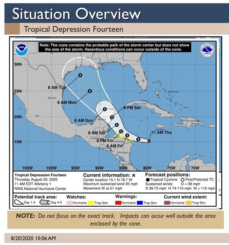
Orange County Judge John Gothia issued a Disaster Declaration for Orange County today.

County and City Officials are recommending a VOLUNTARY EVACUATION for all of Orange County and all of its Municipalities due to the uncertainty of Hurricane Marco and Hurricane Laura.

At this time Officials are issuing a mandatory evacuation FOR nursing homes ONLY.

There is NOT a mandatory evacuation for Orange County Citizens at this time. Officials are meeting and will make that decision this afternoon after the weather briefing.

Judge Gothia has directed the Orange County Courthouse and Non-Emergency Offices will close Tuesday, August 25, 2020.

Emergency response office will remain open.

Sandbags Available from City of Orange

in Weather
Sandbags Available from City of Orange

The City of Orange will open a sandbagging location effective Monday, August 24 at 12 P.M. at Memorial Field, located on Eddleman Drive near Meeks Drive.

Citizens will be limited to 20 sandbags per household.

Please be aware, this is a self-serve station while resources are available. Residents will need to provide their own shovels and be prepared to self-fill sandbags.

Marco and Laura Update Aug. 24 at 10 AM

in Weather
Mandatory Evac Issued for Orange County Nursing Homes - Voluntary Evac for Others

The City of Orange Office of Emergency Management continues to closely monitor both tropical systems that are approaching the Gulf of Mexico. The US National Weather Service Lake Charles Louisiana currently has low to medium confidence in the track and intensity of both systems.

Marco updates:
Marco continues to weaken and is not expected to cause any weather problems in our region today or tomorrow.

Laura updates:
Laura is expected to make landfall between southeast Texas and south-central Louisiana as a category 2 hurricane late Wednesday or early Thursday. Here are the expected weather impacts from Laura:

  • Winds: Hurricane-force winds will be possible across the region starting late Wednesday and continuing Thursday.
  • Storm Surge: At the coast, water could be over 10 feet above ground level. Depending on where Laura makes landfall, storm surge can back up rivers and bayous and flood over 30 miles inland.
  • Rainfall: Depending on where the rain bands form, 5 to 10 inches with locally 15 inches will be possible starting Wednesday into Thursday.
  • Tornadoes: Tornadoes will be possible in the eyewall as the hurricane approaches the coast, as well as outer rain bands.

Citizens are encouraged to continue monitoring local media sites such as weather.gov/lakecharles and official social media outlets for current information.

Southeast Texas Watching Tropical Depression 14

in Weather
Southeast Texas Watching Tropical Depression 14

 Tropical depression 14 has formed in the central Caribbean Sea Thursday morning. The system is expected to become a tropical storm later today then track to the Yucatan Peninsula Saturday before re-emerging in the Gulf of Mexico on Sunday.

Beyond Sunday, uncertainty is high regarding the track and intensity forecast. Any possible impacts to South-Central Texas would occur during the middle part of next week.

The forecast will be refined through the weekend as confidence increases.

1 5 6 7
Go to Top