Category archive

Weather - page 4

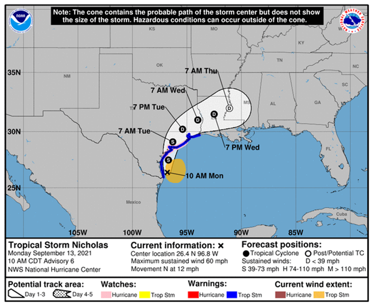
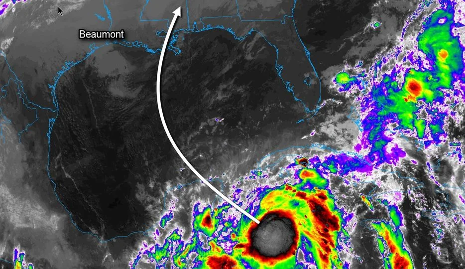
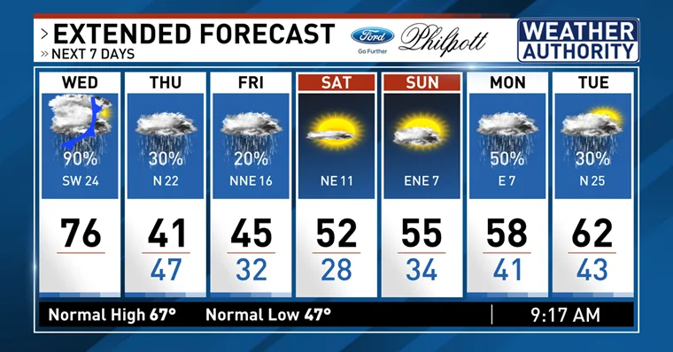
Cold Weather Ahead for SETX

in Weather
Image from KFDM News

According to the National Weather Service – Lake Charles, our region can expect to see a cold front push through late Wednesday evening into early Thursday morning and continue through the weekend with a good coverage of showers and thunderstorms. Colder air will return Thursday through the weekend with some sleet possible Thursday night. Freezing temperatures for lows look likely Friday and Saturday morning.

According to KFDM News here’s the weather forecast for the Golden Triangle:

Wednesday: Mostly cloudy skies w/ 90% coverage of showers and t-storms. Highs in the middle 70’s. Winds: SW 16-32 mph.

Tonight: Overcast skies w/ rain ending. Overnight lows in the upper 40’s. Winds: N 14-30 mph.

Thursday: Overcast skies w/ 30% coverage of rain. Temperatures slowly falling through the day. Winds: N 14-30 mph.

Preparations should include protecting exposed pipes and faucets, along with protecting pets. Citizens are encouraged to monitor local media sites and official social media outlets for current information.

Tuesday Update on Tropical Storm Nicholas

in Weather

NSW Tropical Storm Nicholas update: 9.14.21 10am

Nicholas will continue to weaken as it slowly moves through the Houston TX area today. Tonight it will slowly turn east and head towards the Beaumont region, before slowing down or even stalling in southwest Louisiana Wednesday into Thursday.

Wind gusts today will be in the 25 to 45 mph range for southeast Texas and southwest Louisiana. A few power outages will be possible. Gusts will be 20 to 30 mph across the remainder of the region.

Rain totals will be 4 to 10 inches, with locally higher amounts possible. Be aware of the road conditions. Traveling is not recommended during flash flood warnings.

Tides will be 1 to 2 feet above normal today and tomorrow. Minor coastal flooding is possible during high tides.

There is only a marginal 5% chance for tornadoes today across most of our region.

Tropical Storm Nicholas Update

in Weather

Tropical Storm Nicholas Update, 9/13/21 @ 10:00 A.M

According to the US National Weather Service Lake Charles Louisiana, Tropical Storm Nicholas is forecast to make landfall on the middle Texas coast later today or tonight. There is a chance it could become a category one hurricane before landfall. Regardless of development, our region is expected to receive 5 to 10 inches of rain, with locally higher amounts possible. Citizens should expect to see street flooding during heavy periods of rain. Our region can expect to see flood conditions through Wednesday. Tides are expected to run 1 to 4 feet above normal in our region, with the higher values in southeast Texas. During high tides, minor coastal flooding is expected.

The City of Orange Office of Emergency Management continues to monitor Tropical Storm Nicholas and will post updates when available.

Citizens are encouraged to monitor local media sites and official social media outlets for current information.

Sandbags Available for Heavy Rainfall Predicted for Orange Area

in Weather

According to the National Weather Service – Lake Charles, today marks the first of several periods of heavy rain and storms in our region. Severe storms are possible throughout the afternoon.

During periods of heavy rain, roadways may begin to hold water. If you notice water over the roadway, turn around. Do not drive through high waters.

The City of Orange Office of Emergency Management encourages citizens to monitor local weather channels for current weather updates and additional information.

Orange County has sandbags available at the following locations.  You will need to bring your own shovel to fill the bags.

  • Precinct 1 County Maintenace Barn located on Hwy 87N at North Teal Rd.
  • Precinct 2 11897 State Highway 62 in Mauriceville across from Marketing Basket on Highway 62
  • Precinct 3 County Maintenance Barn on 2502 West Roundbunch Road
  • Precinct 4 County Maintenance Barn on 375 Claiborne St.


Zeta Expected to Bring Rain to SE Texas

in Weather
Zeta Expected to Bring Rain to SE Texas

According to KFDM Meteorologist Greg Bostwick, Zeta is nearing hurricane intensity and will move across the northeastern sections of the Yucatan Peninsula tonight. By tomorrow morning, Zeta should be in the southern Gulf with a gradual turn to the north Tuesday afternoon. Conditions in the southern Gulf are favorable enough for Zeta to be a hurricane but weakening will be likely as it nears the northern Gulf coast and encounters wind shear along with cooler water temperatures.

Landfall is expected Wednesday afternoon near the mouth of the Mississippi as Zeta turns sharply to the northeast ahead of a front moving into the northwestern Gulf.

Locally, scattered showers can be expected Tuesday and Wednesday as some of the moisture of Zeta interacts with the front moving in from the northwest. Otherwise, any significant weather should stay well to our east.

Go to Top