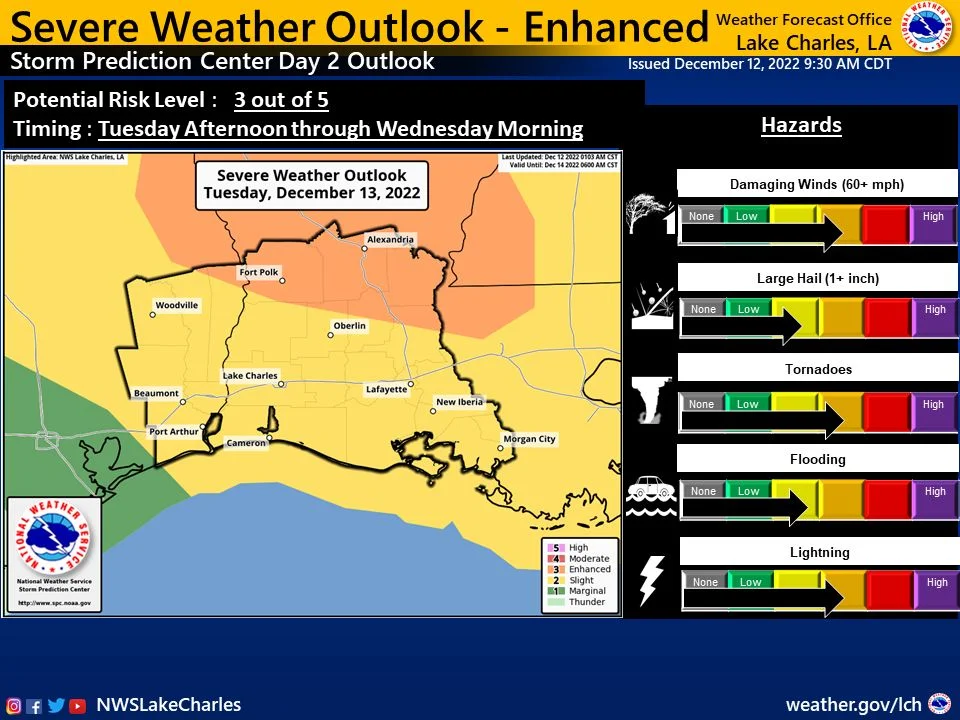
Category archive

Weather - page 3

Orange County Disaster Rebuild Sponsors Disaster Intake Event

in Events/Government/Weather

Are you still in need of disaster recovery assistance from any of the recent natural disasters that have struck  Orange County since 2017?

Orange County Disaster Rebuild will be having an intake event on May 3, 5, 10, and 12. 2022, from 10 am – 4 pm at the Orange County Convention & Expo Center located at 11475 FM 1442; Orange, Texas 77630.

Please see the flyer below for more information.

SETX Disaster Expo Scheduled for April 23

in Events/Weather

Jefferson, Orange, Hardin, and Jasper counties will host a Southeast Texas Disaster Expo at the Ford Park Exhibit Hall. The event is free to the public and will take place on Saturday, April 23 from 10 a.m. to 4 p.m. It is free to the public thanks to community partners and sponsors.

The goal of the expo is to make sure community members are better prepared for potential disasters including flooding, industrial incidents, and hurricanes.

Two years ago, Jefferson County Judge Branick and his Jefferson County Emergency Management team began working with a local business to host a disaster expo for our area. The goal was to better prepare and inform area residents for potential disasters, including flooding, industrial incidents, and hurricanes. Unfortunately, the Covid-19 Pandemic, as well as other major incidents, delayed the event.

With increasing population, new construction, and infrastructure, Southeast Texans are faced with more challenges during disasters. We have responded to and persevered through numerous natural and manmade disasters. We learn more from each incident and have a wealth of knowledge and experience to share.

Presenters will include area, state, and federal elected representatives.

Community members are invited to bring their families. There will be activities for the kids, free food, and more than 40 booths and displays.

Orange County Storm Risk Management Program Schedules April Open Houses

in Government/Weather

Devastating storms have plagued the coast of Texas for decades, claiming thousands of lives and damaging homes, businesses, infrastructure, and ecosystems in the process. The Sabine Pass to Galveston Bay Coastal Storm Risk Management Program (S2G) has been established to deliver a cost-effective, ecologically-sound solution that will reduce coastal storm surge risks to residential structures, industries, and businesses in Orange, Jefferson, and Brazoria Counties to ensure the Texas coast remains resilient for years to come.

The S2G Program is comprised of three Coastal Storm Risk Management (CSRM) Projects: improvements to existing hurricane flood protection features in the Freeport and Port Arthur regions, and the construction of a brand new system in southern Orange County.  The Orange County project will consist of a new levee system, including multiple pump stations, which aims to reduce the risk of storm surges for Bridge City,West Orange, Orange, and unincorporated areas of Orange County.

They will host several public open houses being held n April to view informational displays and for officials to answer questions.

The open houses are:

  • Tuesday, April 26. 2022, from 5-8 PM at Bridge City Community Center, 105 Parkside Dr., Bridge City
  • Thursday, April 28. 2022, from 5-8 PM at American Legion Post 49, 108 Green Ave., Orange
  • Saturday, April 39, 2022, from 10 AM – 2 PM at Orange County Convention and Expo Center, 11475 FM 1442, Orange.

More info about the project is available online here.

Cold Weather Ahead for SETX

in Weather
Image from KFDM News

According to the National Weather Service – Lake Charles, our region can expect to see a cold front push through late Wednesday evening into early Thursday morning and continue through the weekend with a good coverage of showers and thunderstorms. Colder air will return Thursday through the weekend with some sleet possible Thursday night. Freezing temperatures for lows look likely Friday and Saturday morning.

According to KFDM News here’s the weather forecast for the Golden Triangle:

Wednesday: Mostly cloudy skies w/ 90% coverage of showers and t-storms. Highs in the middle 70’s. Winds: SW 16-32 mph.

Tonight: Overcast skies w/ rain ending. Overnight lows in the upper 40’s. Winds: N 14-30 mph.

Thursday: Overcast skies w/ 30% coverage of rain. Temperatures slowly falling through the day. Winds: N 14-30 mph.

Preparations should include protecting exposed pipes and faucets, along with protecting pets. Citizens are encouraged to monitor local media sites and official social media outlets for current information.

Tuesday Update on Tropical Storm Nicholas

in Weather

NSW Tropical Storm Nicholas update: 9.14.21 10am

Nicholas will continue to weaken as it slowly moves through the Houston TX area today. Tonight it will slowly turn east and head towards the Beaumont region, before slowing down or even stalling in southwest Louisiana Wednesday into Thursday.

Wind gusts today will be in the 25 to 45 mph range for southeast Texas and southwest Louisiana. A few power outages will be possible. Gusts will be 20 to 30 mph across the remainder of the region.

Rain totals will be 4 to 10 inches, with locally higher amounts possible. Be aware of the road conditions. Traveling is not recommended during flash flood warnings.

Tides will be 1 to 2 feet above normal today and tomorrow. Minor coastal flooding is possible during high tides.

There is only a marginal 5% chance for tornadoes today across most of our region.

Go to Top